ANCIENT SACRED SITES TRIANGULARLY ALIGNED BY THE FOOTSTEPS OF THE GODS.
Ancient architects not only placed temples sharing commonalities according to perfect triangles, they did so from the sky and across vast distances.

The Hindu Trimurti is the eastern equivalent of the Holy Trinity, in which the gods Vishnu, Brahma and Siva represent the three faces of the central godhead. In the Rig Veda there exist numerous accounts of Vishnu's unusual behaviour of "measuring out the Earthly regions, thrice setting down his footstep." Given that sacred texts and myths are marvellous containers for great concepts, and that so many ancient sacred sites are said to be the manifestations of the energy of gods, is it possible that temples and other sacred places were once placed according to the geometric representation of the trinity: the triangle?
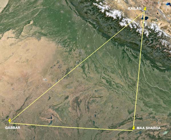
The advent of satellite imagery now makes it possible to accurately prove such grand concepts, although the angles themselves are measured at ground level. Take the three mountain shrines throughout the Indian subcontinent specifically associated as abodes of Siva (an aspect of Vishnu) — Mount Kailas, Maa Sharda and Gabbar — which also double as repositories of the knowledge of the gods or their superabundant energy. The three form a perfect right-angle triangle covering over 1600 miles.
The same plays out in China, with the three holiest mountains in Taoist faith — T'ai Shan, Heng Shan and Hua Shan — all repositories of a cosmic force, all associated with the Otherworld and renewal of the soul, all used since Paleolithic times: all connected by an isosceles triangle, centered on their respective man-made shrines.
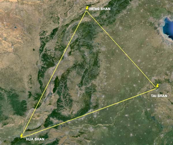
Chinese Taoist sacred mountains and shrines align to an isosceles triangle.
Skeptics will quickly point out that any features can be chosen at random to create fictitious alignments. Perhaps. But when the chosen sites all share a number of commonalities, it lowers the odds of chance and raises the probability that such geodetic precision was deliberate. If the pattern is repeated elsewhere, the odds of chance dwindle considerably.
Consider the following Andean sites. Tiwanaku ('the navel at the center') is a megalithic complex built by the god Viracocha and seven Shining Ones following a global catastrophe that wiped out most of the Earth. One of Tiwanaku's oldest components is the semi-subterranean temple, where stand three pillars that are reminiscent of a massive geoglyph, carved onto a hillside 500 miles away in Paracas, which depicts three flaming uprights forming a 'Tree of Knowledge'; local folklore suggests Paracas was the landing place of the aforementioned gods. The same story appears in a third location, Cuzco (also a ‘navel of the earth’), where Viracocha traveled to after building Tiwanaku, and where the knowledge of said gods was deposited. Three sites sharing identical purpose, myth, and possibly, age, form a perfect isosceles triangle, Tiwanaku and Paracas being equidistant from Cuzco. The path connecting them stretches over 1100 miles.
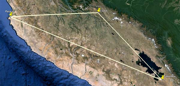
The Tiwanaku - Cuzco - Paracas triangle.
Cuzco itself forms a trinity with two local sites, Saqsayhuaman and Q'uenqo. The three once formed part of a procession associated with an initiation ritual where candidates entered the Otherworld and returned enlightened. Despite the two latter temples being located out of sight on the steep hill above the city, the three are nevertheless connected with absolute precision by an isosceles triangle. Interestingly, the actual point on Saqsayhuaman is a megalithic, horseshoe shaped enclosure that neatly holds the imaginary line from Cuzco.
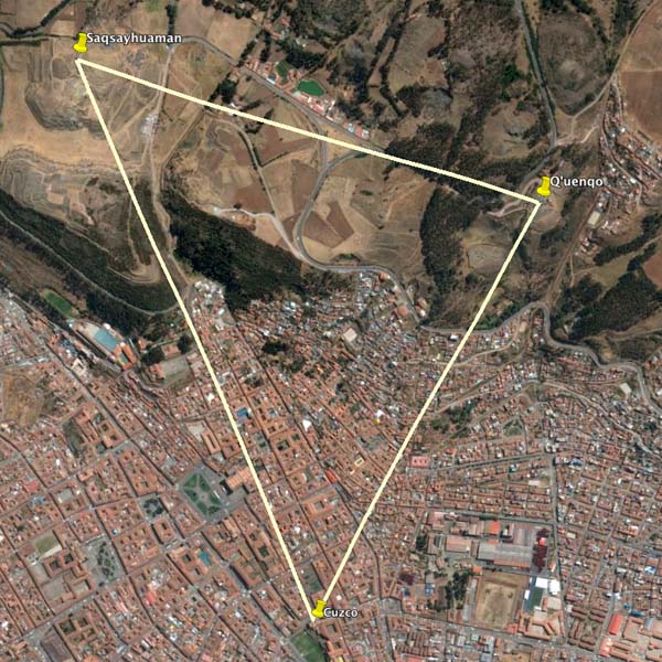
Cuzco - Q’uenqo - Saqsayhuaman triangle.
Viracocha and his seven colleagues are an echo of the Egyptian Aku Shemsu Hor, literally ‘Shining Ones, Followers of Horus’. Egyptian texts describe them as survivors of a catastrophic global flood, after "seven burning mountains destroyed the Earth." These gods were entrusted with “resurrecting the former world of the gods,” which they undertook by rebuilding sacred sites along the Nile, starting at On, and then extending their work abroad. The temples they built are mirror images of the perfection of the heavens, and since the sky was the abode of gods — which in ancient times were interchangeable with the forces of nature — it stood to reason that the ancient sacred sites were also be living images of the gods themselves.
The triangular scenario plays out in other parts of the world. Japan's three oldest and holiest Shinto shrines — Mt. Miwa, Mt. Haku and Mt. Fuji — form a perfect right angle triangle. Across Yucatan, the temple complexes of Palenque, Tikal and Copan (all sharing the oldest cosmologies, repositories of knowledge, and myths of gods arriving after a global flood) form a perfect isosceles triangle. In Greece the three sites of remote antiquity are all 'navels of the earth', abodes of the gods and repositories of their knowledge — Mt. Olympus, Delphi, Dodona — all anchored by an isosceles triangle, with Dodona and Olympus being equidistant from Delphi.
In the Navajo and Hopi lands, Mt. Taylor, Bell Rock and Shiprock share the same functions as portals in and out of the Otherworld; they are linked by a perfect right-angle triangle. As are the three hill sanctuaries of ancient Ireland: Knocknarea, Uisneach and Croag Padraig.
But why, out of all possible geometries, choose the triangle?
The choice has scientific merit, for the triangle is the two-dimensional representation of the tetrahedron, the bonding shape behind all molecular structures, hence why the tetrahedron has been referred to as 'the glue of God'. It follows that to align sacred sites in perfect triangles would bestow such places with the very essence of stability and creative power, at least symbolically.
The ability to perfectly triangulate sacred sites without a visual bead across hundreds, even thousands of miles, often across undulating or mountainous territories, and without the aid of an eye in the sky, poses new questions about the mythical builder gods, all of whom are described in multiple cultures as people of extraordinary intellect and intuitive acumen.
The concept of the triple steps of Vishnu is also assisting with the latest research into recreating a lost web of once connected sacred sites and man-made temples. Recently it was discovered that two of England's most iconic man-made conical mounds — Silbury Hill and Merlin's Mound —are not only linked by age, function, shape and latitude, but a third, forgotten but now destroyed mound was discovered at Wilcot to the south. The three are exactly 5.2 miles apart and form a perfect equilateral triangle.
Returning to Tiwanaku, its oldest structures are anomalous in that they are misaligned from true East by exactly 4º, as though they belong to a different age: the artificial hill Akapana, and nearby Puma Pumku. The two don’t immediately suggest a relationship, but when one visits the cathedral in the nearby village, one cannot be but gobsmacked by the disproportionate scale of this edifice relative to its rural community. Was the cathedral built over an existing temple, in keeping with Catholic practice? When this is taken into account, the altar of the cathedral forms a perfect equilateral triangle with Puma Punku and Akapana.
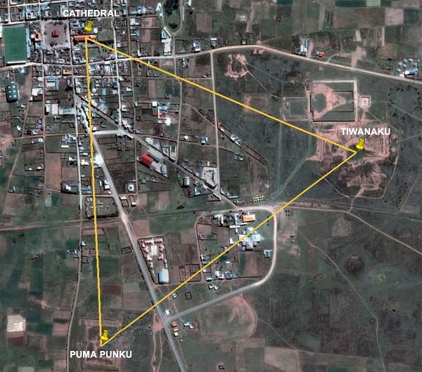
Triangle alignment at Tiwanaku.
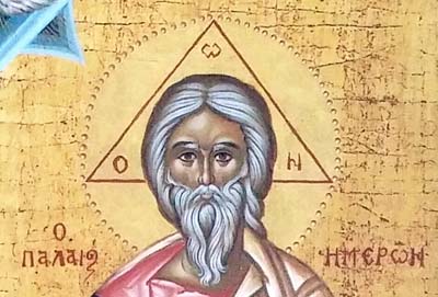
Did ancient surveyors once think in triangles to draw the energy of the heavens to Earth? It's likely. After all, even in Christian iconography, God is the only individual depicted with a triangular halo.
©Freddy Silva. No reproduction without permission.
