Ancient mysteries and alternative history by bestselling author Freddy Silva

GOBEKLI TEPE:
THE OTHER HILL OF OSIRIS


A re-examination of the site reveals an Egyptian connection and an astronomical alignment to Vega and Orion.

Placeholder Picture

The naming of places in the ancient world was a serious affair, particularly with regard to temples. A name enshrined the purpose for which the site was intended, or reflected a truth about its history. Thus understanding the real name of Göbekli Tepe offers the greatest clue as to why people of a forgotten era created a monument that is both out of place and out of time.

Its ancient Armenian, and probably oldest name is Portasar, and it breaks down into two syllables: port (navel or umbilical cord), identifies the site as a Navel of the Earth, a seeding place where the knowledge of the gods was first deposited. Where such epicenters exist throughout the world, wisdom spread across the land like ripples, touching the uncivilized and the brute and elevating the potential of humankind.

The second syllable asar is revelatory, for it is none other than the original name of Osiris, primary Egyptian deity and lord of the Otherworld. It can be said, then, that this hill is the Umbilical Cord of Osiris.

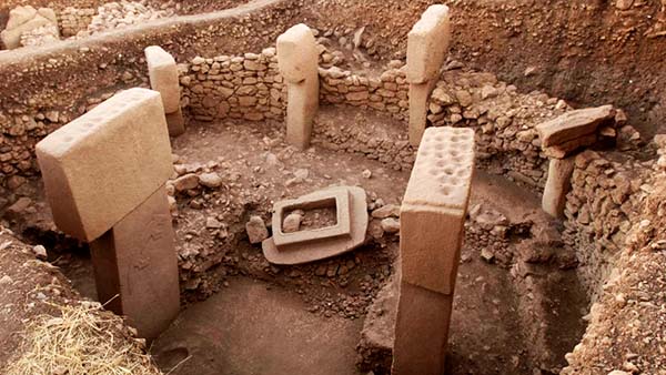
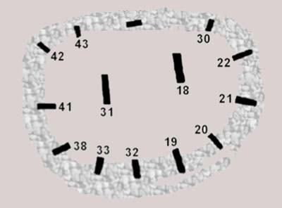
Portasar’s most fascinating stone circle is Enclosure D. Its organic material has been carbon-dated to c.10,500 BC 1 suggesting people were present here three hundred years after the meteorite strike that triggered the Younger Dryas epoch. By the same token, C-14 dating of the wall mortar protecting this enclosure offers a range of 9990-9600 BC, suggesting activity at the site one hundred years either side of the meteor strike that generated the great flood and the end of the Younger Dryas. It would appear that someone came to this hill in Anatolia to construct what appears to be an observatory or a library in stone, then carefully packed up the site and left prior to the destruction about to unfold.

Placeholder Picture

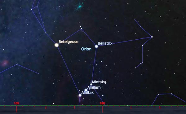
The north view above Gobekli Tepe enclosure D on the winter solstice 10,500 BC.

What does astro-archaeology have to say about the actual construction date of Enclosure D, the one featuring thirteen T-shaped pillars, each carved with a plethora of animals and symbols in relief, many with astronomical connotations? It has been suggested that the pillars were aligned to reference the setting of the northern constellation Cygnus.2 It is an elegant theory except it omits one glaring obstacle: the stone circle is not on the summit of the hill but sits approximately twenty-five feet below the horizon line, making it near impossible to observe and mark descending or ascending objects with any accuracy in the northern sky.

Secondly, with rare exceptions, ancient people typically commemorated the rising of astral objects or their highest position in the sky, not their setting.

Perhaps a reexamination is in order. As the Sun descended below the horizon on the winter solstice in the epoch of 10,500 BC, a person standing in-between the two massive central pillars looking north would see Vega, the star then closest to the celestial pole, glistening like a jewel at 352º, the same alignment as the central pillars; Vega's position is marked by pillar 43 along the perimeter, while its 20º elliptical rotation around the celestial pole from sunset to sunrise is framed within the field of vision of said pillars. Most importantly, Vega's altitude at the time makes it clearly visible above the summit.

Placeholder Picture

The view south between the pillars of Gobekli Tepe, winter solstice 10,500 BC.

Vega’s name derives from the Arabic waqi (falling, swooping), and refers to a time when the rotation of its host constellation Lyra was seen as a swooping vulture.3 That was during the epoch of 10,500 BC. This might explain why pillar 43 features a prominent relief of a vulture with outstretched wings, one of which touches a circle; two smaller, less mature vultures stand either side. Seen together the birds appear to be describing Vega’s circling of the celestial pole, and its diminishing brightness as it completes this nightly circumpolar journey.

The siting of Enclosure D below the summit suggests the northern sky was perhaps not the primary aim of the monument. Turning to face south at the same time Vega appears in the north, the belt of Orion rises briefly above the horizon, it’s narrow arc framed by pillars 19 and 33, with pillar 32 marking the constellation’s highest ascension in that era.

By comparison, the epoch of 9600 BC — the late C-14 date for Enclosure D — sees Vega rising 10 degrees further to the west, well outside the alignment of the central pillars and certainly out of alignment with pillar 43; meanwhile Orion has barely shifted a few degrees to the southeast and remains acceptably within the pillars' frame of reference.

Placeholder Picture

Plan of Enclosure D.

So, what are we to make of this combined reference to the pole star and the ascent of Orion’s Belt c.10,500 BC? Taking the hill's original name Portasar — the Umbilical Cord of Asar — Osiris is himself associated with Orion, and his dwelling place is Giza, the plateau identified in Egyptian texts as Rostau, a gateway to the Otherworld. Robert Bauval and Adrian Gilbert have convincingly shown how the foundation plan of the three main Giza pyramids mirror the alignment of Orion's belt during the epoch of 10,500 BC, this time during the spring equinox, while the central pyramid references the north celestial pole.4

Could Göbekli Tepe be an Armenian Giza Plateau, an extension of the house of Osiris? Certainly there exists a geodetic relationship between the two locations. Taking the 39.6º alignment through the corner of the pyramids of Menkaure and Khufu, an umbilical cord extends 700 miles along the surface of the Earth to Göbekli Tepe. The margin of error is 1.5º, a miniscule discrepancy given ten thousand years of plate tectonics.

Placeholder Picture

Pillar 43. Gobekli Tepe.

Göbekli Tepe's deliberate southeastern exposure and siting below the summit isn't just referencing the sky. If one follows the central T-pillars of Enclosure D, finessing the eye through pillars 32 and 19, it is possible to see the ancient observation tower of Harran twenty-five miles away which, back in the day, was far taller and served as a landmark.

Harran lies in what used to be north-western Mesopotamia, and archaeological artifacts date human activity in the region to c.8000 BC. Its earliest name was Harranu, the nearest translation being Path of the Anu. It was once a major center for astronomy and home to the Sabeans, a group of sages who were among the ancient world’s keenest observers of the stars;5 in fact the name derives from the Egyptian Sba (star).

© 2018 Freddy Silva. Extract from the forthcoming book The Missing Land.


REFERENCES
1. Schmidt, Klaus, Göbekli Tepe: The Stone Age Sanctuary in South-Eastern Anatolia, Ex Oriente, Berlin, 2012, p.243; How Old Is Göbekli Tepe? The Tepe Telegrams, 6/12/2016
2. Andrew Collins and Rodney Hale, www.andrewcollins.com/page/news/P43.htm
3. Michael Anissimov, www.wiseGEEK.com
4. Bauval, Robert, and Gilbert, Adrian, The Orion Connection, Heinemann, 1994
5. Prag, Kay. The 1959 Deep Sounding at Harran in Turkey, Levant 2, 1970, p.71-2

Placeholder Picture

To read more about this topic, consider this book.